top of page
Geological Interpretation at prospect or regional scale in order to generate well-established geological and tectonic model which minimizes exploration risk and is instrumental to achieve reasonable mineral system model.
3D Modelling and Integrated Interpretation of conventional potential fields (Gravity and Magnetics), Airborne Gravity Gradiometer (AGG) and EM
Mineral Potential Mapping based on geological and geophysical interpretation
Exploration Advice tailored according to clients requirements. Interpretation maps in a form of GIS and 3D digital models are accompanied by explanatory technical reports. The reports discusses the data employed, the interpretation workflow, the results and if requested, recommendations for an follow-up exploration
Drilling Programs and Geophysics Programs under the Exploration Incentive Scheme (EIS) studies and applications in Western Australia
Reporting of Exploration Results (JORC code)
Review of geological and geophysical data of existing or soon to be acquired tenements
Downhole structural, lithological and petrophysical interpretation


A three-dimensional geologic model consistent with the gravity, magnetic, seismic and well data. Western Australia
Detailed geological interpretation of airborne magnetic and radiometric data. Queensland
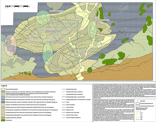
Airborne magnetic and radiometric data interpretation for prospect identification and subsequent drill planning. The interpretation covers a contiguous area of 554 km2 in Central Zambia.

Downhole lithological and petrophysical interpretation. Western Australia
bottom of page